
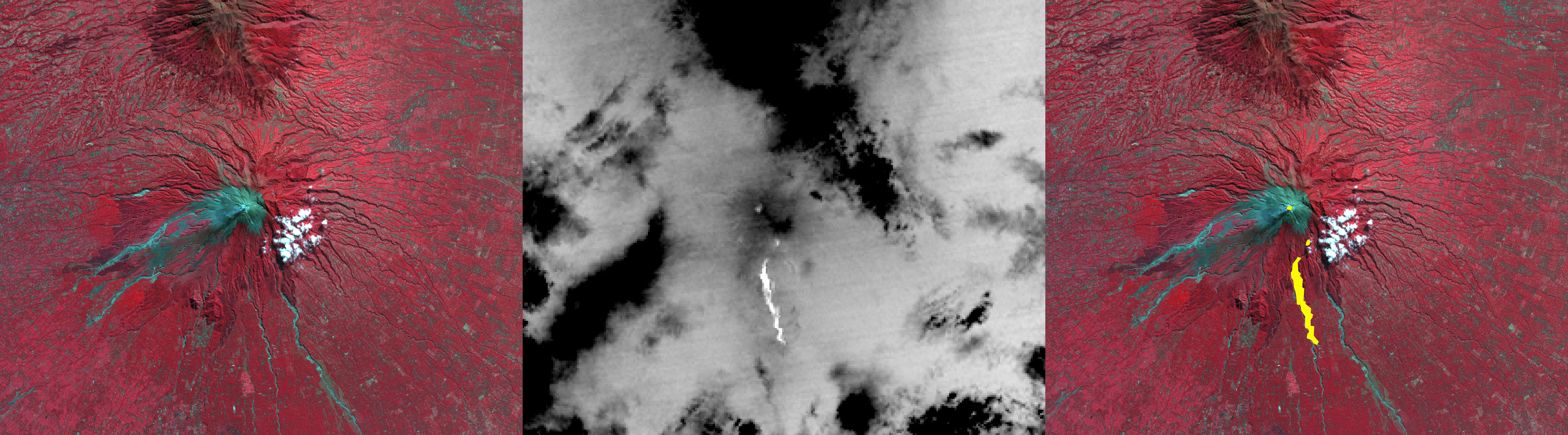
On October 26, 2010, Merapi volcano in Indonesia erupted, killing at least 38 people and prompting authorities to evacuate tens of thousands of inhabitants from around the mountain. On the night of October 30, the Advanced Spaceborne Thermal Emission and Reflection Radiometer (ASTER) instrument on NASA's Terra spacecraft captured a thermal infrared image (center Figure 1) of the hot volcanic flow that resulted from collapse of the summit lava dome, and that led to the ensuing release of ash plumes (center Figure 1; hot areas are brightest). In the daytime image from 2003 (left Figure 1), vegetation is displayed in red, and older volcanic flows are in blue-gray. The composite image on the right superposes the hot flow and summit dome areas from 2010 in yellow on top of the 2003 image. Gaps in the hot areas are due to concealment by intervening clouds in the 2010 night infrared image. The ASTER image is located at 7.5 degrees south latitude, 110.5 degrees east longitude. The image covers an area of 17 by 19 kilometers (11 by 12 miles).
With its 14 spectral bands from the visible to the thermal infrared wavelength region and its high spatial resolution of 15 to 90 meters (about 50 to 300 feet), ASTER images Earth to map and monitor the changing surface of our planet. ASTER is one of five Earth-observing instruments launched December 18, 1999, on Terra. The instrument was built by Japan's Ministry of Economy, Trade and Industry.
Photo credit: NASA/GSFC/METI/ERSDAC/JAROS, and U.S./Japan ASTER Science Team
Update: Another, less impressive image from ASTER can be found at PIA13607: Merapi Volcano Continues its Destructive Eruption.
Update #2: Another set of photos (visible light and infrared) from NASA: PIA13634: ASTER Images Merapi's Continuing Eruption, (released 18 November 2010).
No comments:
Post a Comment